Show Posts

This section allows you to view all posts made by this member. Note that you can only see posts made in areas you currently have access to.

Messages - a046

Pages: [1]
1
Hello all,

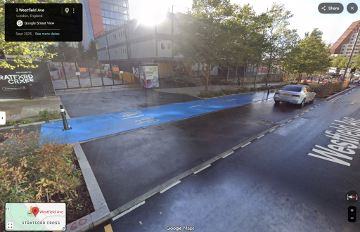
Got an NIP for 29 in a 20, heading eastbound here on Armada Way:

https://maps.app.goo.gl/u6fUS859BJNW2N997

(Bit of a silly place for a 20 limit but ho-hum)

I drive around here very often and come at it from multiple approaches at the nearby (Gallion's Reach) roundabout, so not sure which path I took this time.   Most likely I came off either Gallions Road or Royal Albert Way, both of which are 40 mph.

From Gallions Road in particular there's a 30 mph sign here at the roundabout entrance:

https://maps.app.goo.gl/FSH9auNu3qcHrFWr8

But I don't think there's another 20 mph sign before Armada way, and I can't find one on Street View.

From Royal Albert Way there is a 20 mph sign at the entrance here:

https://maps.app.goo.gl/CPaG54DvqpuRWwn6A

Which obviously conflicts with the 30 mph at the Gallions Road entrance.

There is a roundel here on Armada way:

https://maps.app.goo.gl/v3dNWq8dkBhfxG5c7

But not sure how much weight that holds with the conflicting signage.

Thoughts?  Not sure if Newham publishes TROs online somewhere, but I'll try to find it.

2
For posterity/forum record: they accepted informal reps on wrong location.  Success.

3
For posterity/forum record: lost/gave in/ended up paying this one.

4
Hello all,

Went down a side street to stop and take a phone call.  Didn't realize I was entering the zone, signage is turned the wrong way to be seen on approach.  Left by the nearest exit.  Didn't get a PCN or anything but charged on autopay.  Contacted TFL but they rejected out of hand (of course). 

Anywhere to go from here? 

Naturally I can share details properly, but I'm not even sure there's a path to appeal this or what it would look like.

5
Yeah, I'll probably just do an informal rep on that basis, hopefully they'll give in quick and not draw the whole thing out. 

Actually I think they have newer street view now, not sure why it wasn't showing in my link before:

https://maps.app.goo.gl/mpdZg3YqAMYVjqQB7


It's like this at present but they removed the dashed lines and added the hatchings on the RHS.  The access and gate are still there though, so it's funny that it used to be explicitly marked as a side road with the same bricks/leveling.  At least I think it's marked as a side road, since all the other bays are much more properly marked.  Raised kerbs at both sides as well.

The car on street view is where I was parked too.  Actually I've been parking here since the old markings with no problems, just always assumed it was a hodge podge bit of private land.

6
Hello all,

Parked on a weird bit of tarmac next to the road to load (pick up food).  Hard to describe in words (see pics), but it's an area between the cycleway and the road proper, which is also used to access the construction site to the left.  The surface is level with the road, although it does have some inset bricks to mark the edge.  I wasn't blocking the side road because there's an offset (and it's quite wide anyway).  Also there are hatched markings, although they look a bit odd.

No signs of any kind that I could see.  I'll be honest, I thought it might be private land given it's such a big office/commercial development around that area, but I saw no signs, wasn't inconveniencing anyone else, and thought it would be fine.


PCN info:

PCN number: PN25190367
Vehicle registration: MK71ZPW
Date of contravention: 04/03/2026
Location: Honour Lea Avenue, opp hse 5, Stratford
Contravention code: 62 - Parked with one or more wheels on or over a footpath or any part of a road other than a carriageway
Issuing authority: London Borough of Newham


Other pics

Still waiting on Newham to upload, but here's one I took in the interim:


Location

Google Street View is quite useless because it looks totally different now (see pics), but here is where I actually parked:

https://maps.app.goo.gl/xFdRfaAxkaMUp7c47

And here is what the PCN lists as the location:

https://maps.app.goo.gl/xh9WxaVKCr48wamq8


Point(s) of appeal

Location stated is totally wrong.  It references Honour Lea Avenue, whereas I was parked on Westfield Avenue.  Think that's fatal enough for this PCN, but I wonder if I could get your learned opinions on this spot in general, since I often have to pick things up from this location.

Ultimately I would say this is in fact a carriageway.  It's there for access to the site and surely we don't put hatched markings for pedestrians on footways, only on roads for vehicles.  Thoughts?

7
Although actually I might have misunderstood it again.  It says the pay by phone bay next to the car club bay with an arrow pointing left.  But the bay is to the right.  To the left are only resident's bays.  So I assume they actually meant the bay to the right and I couldn't have parked there anyway.  But then again I might have argued the ambiguity point if I had!

8
Yes, was just in a hurry and did a rushed check to confirm a (wrong) assumption.

Unfortunately as well I think I could have just parked one bay closer to the car club bay/the sign, since it's specifically the one outside the entrance of number 3 that's suspended, along with the one to the left of the car club bay.

Ironically the car club is dead as far as I know, so no-one could possibly need to use the space for that.  Not that it helps my case.

Thanks for having a look anyway

9
Hi all,

I received a windscreen PCN (code 21u — parked in a suspended bay) while parked on Stanford Road in RBKC. I haven't made any payment or representations yet. I'd appreciate any advice before I do.

I'm thinking I might just have to chalk it up to experience on this one, but would be happy to hear otherwise. Thanks in advance!

What happened:

I parked on Stanford Road to attend an appointment. When I arrived, I noticed some construction hoardings on the street with a parking suspension notice attached to them. The space I parked in was a few spaces away from these hoardings.

I assumed the suspension applied to the spaces directly in front of the hoardings. I gave the notice a quick read and confirmed that--a car club bay immediately in front was listed as suspended.

What I failed to notice was that the same sign also listed a second suspension for "outside number 3", which turned out to be the space I parked in. Because the sign was physically attached to the hoardings and several spaces away from my bay, I didn't associate it with where I'd parked.

I did pay for the parking via app.

Photos:

PCN:


Suspension notice on the hoardings:


Street View:

Here's the street view next to the hoardings/number 3. You can see the hoardings in the Street View, but they've been extended out over the pavement now (see pic attached).

https://maps.app.goo.gl/1pjBysQe7Rmx9qaW7

Pages: [1]